3 What it takes: Establishing sustainable SIS in Africa
3.1 The role of soil information systems in Africa
This section discusses the three main functions of soil information systems: provision of infrastructure to manage soil information, serving soil data and information, advisory and decision support , and an interactive platform for improving soil data exchange and innovations (Figure 3.1).
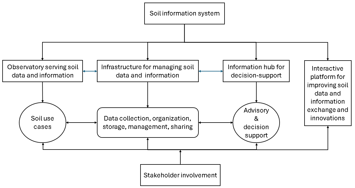
Figure 3.1: Major functions of soil information system
3.1.1 Infrastructure for archiving and managing soil data in digital formats
Soil information system innovation was originally conceived as an online platform for collecting, archiving, and managing soil data and information. This role stemmed from the need to convert soil data, photographs, and maps from hardcopies (also known as legacy data) into digital formats since digital formats are more convenient and efficient to store and share than hardcopies (C. Omuto, Nachtergaele, and Vargas 2013). In this regard, SIS helped to rescue, digitize, and secure hard copy soil data and maps which were otherwise threatened with neglect, loss, or mutilation. This function of SIS is particularly important for most countries in Africa where large amounts of soil data and maps are still in hardcopies and have remained inaccessible to many users over the years. If national or regional SIS are established, they can help countries to improve storage, preservation, and management of such data in digital formats. Examples of SIS with online archives of soil data and information which Africa can consult include the FAO Soils Portal (https://www.fao.org/soils-portal/en/, accessed on 25 April 2024), the World Soil Survey Archive and Uncatalogued (WOSAC) (https://www.wossac.com/index.cfm, accessed on 25 April 2024), the Soil Data Hub at ISRIC – World Soil Information (https://data.isric.org/geonetwork, accessed on 25 April 2024), and the European digital archive of soil maps (EUDASM) (https://esdac.jrc.ec.europa.eu/resource-type/national-soil-maps-eudasm, accessed on 24 April 2024), among others.
Besides digital aspects of soil data, there are also physically archived soil samples whose information can be linked with the digital information. There is an increased potential to improve access to the stored soil samples if the SIS infrastructure is also linked to the archived soil samples (or museums). Archived soil samples for Africa are lying in many stores or laboratories inside and outside Africa. They carry a lot of beneficial information for monitoring changes in the soil resource (Ayres 2019; Karssies and Wilson 2015; Lawrence and Creamer 2023). Examples of a soil archive can be found in ICRAF’s Spectral Soil Library (https://speclim.icraf.org/) and the soil museum at ISRIC’s World Soil Museum (https://wsm.isric.org/).
3.1.2 Serving soil data and information
Most soil information systems have their core functions in serving soil data and information. The data include primary soil data (i.e., measured soil properties and field observations) or processed information in the form of maps. SIS can vary permission levels to the soil data and provide access through avenues such as downloadable links in online portals, web-based or mobile applications, email correspondence, or portable digital storage devices. They can also allow use of GIS and internet interface facilities on the websites for querying, subsetting, viewing, and exporting data such as through a Mapviewer to improve efficient data access.
Soil data service provision in Africa is not properly coordinated. Most data holders do not have proper formal agreements or networking to jointly serve their data. Therefore, most use-cases of soil data and information for the continent must rely on non-harmonized multiple sources to get the required data. The development of a data strategy and policy can help overcome these issues. A case study of developing a soil and agronomy data sharing policy in Ethiopia can be seen as example of how a community-focused and participatory approach can be effectively applied (CAB International 2024). There is no clear authoritative providers of soil data and information on the continent at all levels to serve the user communities satisfactorily. Suitable and interlinked soil information systems at the national, regional, and continental levels are needed to fill this gap and meet the demand of soil data and information in Africa. There are a few SIS examples in the continent presently serving soil data and information but still need more improvement and scaling up to meet the demand for tabular soil data or high-resolution soil information. Examples include Sudan Soil Information System (SUSIS) (https://susis.sd/, accessed on 24 April 2024), Lesotho Soil Information System (LESIS) (https://lesis.gov.ls/, accessed on 24 April 2024), and National Soil Information System for Ethiopia (NSIS) (http://www.nsis.moa.gov.et/, accessed on 24 April 2024).
There is increased potential to improve access to the stored soil samples if the SIS infrastructure is also linked to the archived soil samples (or museums). Archived soil samples are lying in stores in many laboratories in Africa and carry a lot of beneficial information for monitoring changes in the soil resource (Ayres 2019; Karssies and Wilson 2015; Lawrence and Creamer 2023). Examples of a Soil Archive can be found in ICRAF’s Spectral Soil Library (https://speclim.icraf.org/) and of a Soil museum in ISRIC’s World Soil Museum (https://wsm.isric.org/).
3.1.3 Information hub for decision support
A SIS with adequate soil information built on the FAIR data principles should be the information hub for all decisions requiring soil data. In Africa, several agreements or declarations have been made and translated into programs aimed at improving agricultural productivity and soil health on the continent. Implementation of these programs requires investment and policy decisions that should be supported with appropriate soil information. Well-designed and operationalized soil information systems are therefore needed to provide the required decision support.
SIS not only provides the required soil information for making decisions in the agricultural and environmental sectors but can also offer interpretation of the soil information to improve choice of appropriate decisions. As the information hub, SIS is the best location for interpreted soil information that is otherwise ambiguous to some decision-makers. In particular, smallholder farmers who are the majority stakeholders in the agriculture sector in Africa need interpreted and granulated soil information to make appropriate decisions in their farms (Adolph et al. 2021; Mulu et al. 2022; Nyoni et al. 2024).
Soil information systems can also be adapted or supplemented to offer advisory services through web-based dashboards or mobile apps (Golicz et al. 2020; Tobiszewski and Vakh 2023). These application extensions can relay specific messages targeting certain user communities who need synthesized soil information. SIS in Africa can be designed with such features to target its smallholder farmers, policy makers, consultants, and land managers who need customized short messages in simple non-technical terms. Example applications using these approaches and which Africa SIS can borrow from include Land Information Systems (LandIS) for England and Wales (https://www.landis.org.uk/, accessed on 20 April 2024), New Zealand’s Soil Portal (https://soils.landcareresearch.co.nz/, accessed 4 June 2024), Australia’s National Soil Information System (https://ansis.net/, accessed 4 June 2024), United States National Soil Information System (https://websoilsurvey.nrcs.usda.gov/app/WebSoilSurvey.aspx, accessed 4 June 2024), virtual agronomist (https://www.isda-africa.com/virtual-agronomist/, accessed on 20 April 2024), among others.
3.1.4 Interactive platform for improving data exchange
A sustainable SIS also integrates stakeholders interactively to improve its functionalities. Stakeholders provide the technical support (such as designs, standards, research and innovations, data flows, etc.), organizational structures (management, coordination, human resources, etc.), facilitates institutional environment (regulations, laws, copyright agreements, etc.), mobilizes financial resources, and provides the requisite partnerships (collaboration, network, linkages, contacts, etc.) to improve sustainable implementation, proper function, and relevance of the SIS. SIS provides the platform where stakeholders engage interactively to improve soil data portfolio and data exchange.
3.2 Requirements for establishing soil information systems
Establishing a soil information system requires quality standardized soil data and information, reliable internet connectivity, properly designed soil information system model, quantifiable demand for soil data and information, sustainable institutional arrangements and financing, adequate data harmonization protocols and adherence to standards, and conducive policy and political environment (Figure 3.2). This section discusses these requirements and what they mean for SIS development in Africa.
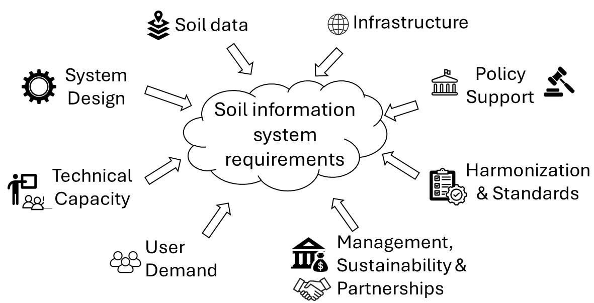
Figure 3.2: Requirements for establishing a soil information system
3.2.1 Soil data
Soil information systems are about soil data and information management. There must be accessible quality soil data for the SIS to be relevant. Although there are many types of soil data the SIS can serve, commonly demanded soil data are tabular analytical data from the laboratories, soil maps, spectral signatures, pedotransfer rules and calibration models (C. Omuto, Nachtergaele, and Vargas 2013). Soil information such as degradation status, fertility/nutrient content, reports, etc. are also popularly demanded by some user communities.
Soil data is available in all countries of the world in different formats, specifications, and spatial and temporal coverage. SIS in Africa needs to organize and harmonize soil data in the continent to appropriately serve the user community. Most countries in Africa still have national level soil maps and soil profile data in non-digital formats. The SIS needs to organize workflows that can transform the data into suitable formats for efficient data onboarding, storage, and management. Furthermore, the workflows can be designed to streamline collection of new data, data contribution from partner organizations, and linkage/cooperation with other soil information systems within and outside the continent.
3.2.2 Digital infrastructure
A SIS is an online facility for soil data and information management. It requires internet connectivity to be able to link with its user communities. SIS should be findable by online search engines, be able carry out data exchange, and allow online data query by users, among other operations (Balla et al. 2020). Implementation of these operations requires steady internet connectivity. Therefore, organizations aiming to deploy and effectively operate the SIS need to ensure stable and reliable internet connectivity.
A SIS is a web service with online or digitally accessible repositories. Therefore, it must have servers on a network for hosting, managing, and serving data to linked users worldwide (Beaudette and O’Geen 2009; O’Geen, Walkinshaw, and Beaudette 2017). Most SIS have remote or cloud servers that must be linked through internet connectivity to accommodate onboarding of incoming soil data, regular updating of data portfolio, and giving users access rights to download or interact with the data. In general, the internet is the artery of soil information systems and SIS will not be able to link with its users and data sources without it. An option for provision of advice to small holder farmers who mostly have less stable internet access is to provide a USSD server access to facilitate SIS services.
In addition to the Information Technology (IT) infrastructure, SIS also requires computing infrastructure to process and store soil data and information. Computing infrastructure includes computers, software, methods or models, and storage facilities (Egmond et al. 2023; CAB International 2024). The methods or models help to streamline data collection, curation and analysis, interpretation, and data organization (including packaging, visualization, and presentation). SIS methods or models are implemented through software in a computing environment. Hence, the need for computers and software.
3.2.3 Appropriate SIS design
The design of a soil information system influences its success in delivering the core functions while maintaining soil data integrity and quality. SIS design is central to its operations and maintenance, linking with and satisfying user demands, accommodating contribution of soil data and information from diverse sources including partner organizations, protecting soil data security, complying with standards, and embracing technological advancements. Available SIS designs in the literature differ according to the roles they target to serve such as discovery hub, data repository, information hub, observatory, etc. (Fern´ndez and Rusinkiewicz 1993; Jacquier, Wilson, and Brough 2012; Kalantzopoulos et al. 2024; Sadovski and Bie 1978; Sousa et al. 2021; Zhong et al. 2014)
In Africa, soil information systems are needed to open up soil data and information access to millions of users across the continent including more than 30 million smallholder farmers, to support policy and investment decisions targeting improvements in agricultural productivity and soil health, and to modernize soil data storage and security in all countries in Africa. Therefore, appropriate soil information systems designs are those that can combine many features that are not common in most existing SIS designs. Table 3.1 shows some of the additional design features SIS in Africa may consider. A more detailed set of guidelines for SIS design and development is available in the framework for strengthening national SIS design (https://resources.isric.org/sis-framework/)
| SIS.level | Design.consideration | Function |
|---|---|---|
| National | Online data repository | Efficient management of soil data |
| Data contribution workflow | Effective data onboarding from many sources | |
| Firewalls and controls | Data security and access | |
| Customizable light deployment | Ease of adoption and operationalization | |
| Web-based and mobile applications | Advisory and decision support options | |
| Multilingual interpretations | Accommodate smallholder farmers | |
| Linkage with higher level SIS | Discovery at regional and higher-level SIS | |
| Regional/Continental | Information hub | Policy and investment decision support |
| Support regional research and modelling | ||
| Data/information contribution nodes | Discovery hub for SIS in member states | |
| Firewalls and controls | Data security | |
| Data/information exchange standards | Harmonize contribution from many sources |
3.2.4 Policy environment and political support
Soil data or information is a national resource that should be properly managed to benefit national development. Although soil data and information are developed and managed by both private and public institutions, governments make policies that govern development, management, and beneficial use of the national soil data and information resource. In the traditional soil surveys, governments plan, fund, and carry out national soil surveys. However, most governments do not seem to take leading roles in the development and management of national soil information systems. Like soil surveys and resultant data and maps, soil information systems need the hand of governments for sustainability. Governments should step in to provide legal instruments, budgetary allocations to manage the national soil information systems, and the political goodwill to promote appropriate use of the soil information resource.
An ICT revolution in Africa has awoken many governments to the potential of information management systems (Beda 2019; David and Grobler 2020; Williams, Mayer, and Minges 2011). Therefore, significant strides have been made in developing relevant policies to regulate and promote ICT in many countries in Africa (Makoza 2022). Since many African countries do not have SIS in place, policies on soil information systems are generally lacking. Countries need to start putting appropriate policies in place to set a vision, define the rules that national system actors need to follow, and to advocate for accelerated SIS development. Policies around ICT in general can be the starting point for guiding SIS policy development. Africa Union Commission (AUC) institutions can be instrumental in providing countries with templates for developing relevant SIS policy for countries in Africa to adopt and customize. AUC institutions can also use their positions and roles to sensitize, mobilize and guide African governments and political class on the benefits and need for SIS at farm, political constituency, and national levels. The campaigns can use different outreach means to reach target audiences.
3.2.5 Capacity building
Soil information system technology is still evolving in many parts of the world. Over the years, SIS concept moved from the simple online information storage and management to service provision using innovations such as artificial intelligence and mobile applications. Therefore, it is common to find SIS nowadays with new applications for crowdsourcing and onboarding soil data and information, artificial intelligence for decision support and advisory services, mobile applications for smallholder farmers, etc. These advancements call for capacity building to help most stakeholders catch up with the SIS trends.
Capacity building in Africa is a top priority for successful and sustainable SIS in the continent. A few considerations are needed for planning SIS capacity development in Africa. Firstly, most countries have technical and staffing challenges to be able to streamline their soil data and information development alongside SIS development. Therefore, they need national staff training to kickstart the journey of NSIS development. Secondly, there is a need for institutional capacity development in many countries in Africa to manage and operationalize NSIS. There are presently very few countries with NSIS. Thirdly, there are dwindling extension services in the continent to link smallholder farmers and advancements in the agriculture sector (Maake and Antwi 2022; Nwobodo et al. 2019). Innovative approaches are needed to build capacity in extension service provision in most countries in Africa (Sanga et al. 2014). Fourthly, there is a need for policy capacity development to promote appropriate and favorable policies for SIS in Africa. This is because most countries in Africa do not have SIS and therefore may not have requisite experience to make policies for SIS integration into their national agenda.
3.2.6 Standardization and harmonization
Standardization requirement ensures that SIS stores and shares soil data and information in conformity to agreed specifications. Standardization is also needed in data collection and processing as a way of safeguarding soil data quality and integrity (Hoffmann et al. 2020; Nortcliff 2002). Besides standardization, SIS also need harmonization strategies to align contributed data from different sources into a common specification. Some SIS designs allow for data contribution from different sources, which may have varied data specifications. Standardization and harmonization allow seamless data movement between different application software with minimal uncertainties due to differences in data specifications. There are many standards and guidelines in the literature for soil data collection, curation, descriptions, harmonization, and data exchange (Arrouays et al. 2014; Hoffmann et al. 2020; Nortcliff 2002). There are complex reasons some standards are adopted and others are not. Nonetheless, open standards should be preferred where possible (https://gatesopenresearch.org/documents/5-74).
SIS in Africa is expected to be multilevel involving national, regional, and continental SIS. There is a need for standardization to allow interoperability and communication between SIS at these levels. Presently, there are many countries in Africa where soil data is still in hard copies, held by different organizations, or in multiple specifications. They need standardization to harmonize digitization of the legacy data and conversion of existing soil data into a common specification. Standardization is also required by countries which are planning to collect new data.
3.2.7 Sustainability
This section discusses three sustainability factors for soil information systems: funding model, institutional arrangements, and enduring partnerships. One of the goals of soil information systems is to remain in operation over a long period of time encountering less frequent downtime/outages, showing timely and effective response to user demand queries, and providing secure, relevant, and quality soil data. The funding model illustrates how SIS gets the finances for its operations and maintenance of steady online presence to interact with its users. Figure 3.3 shows a guideline for designing appropriate sustainable SIS funding model. The guideline envisages models with co-funding at the initial stages and steady budgetary allocations for long-term operations. Funding demands at the initial stage are huge to carter for planning and establishment of necessary infrastructure, acquisition and harmonization of existing soil data and information, awareness campaigns, consultation, and networking, etc. Most SIS typically take 3 to 5 years during the initial funding phase after which they will need steady budgetary allocation to remain in operation for a long period of time.
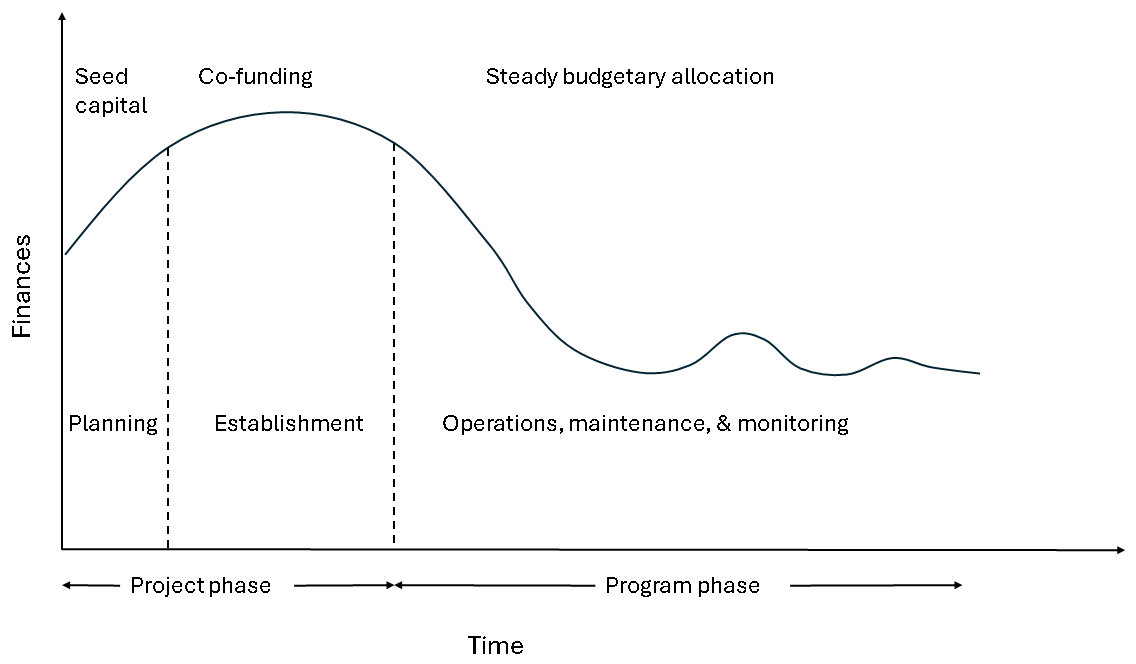
Figure 3.3: Guidelines for designing appropriate SIS funding model
Soil information systems (SIS) in Africa can consider co-funding with development partners at the initial SIS project phases and government budgetary allocations after the project phases. Since most government budgetary allocations are guided by acts of parliament, NSIS need to be legally entrenched in the national development plans to receive annual government funding. This is the most promising way for NSIS to receive both the policy and financial support.
Partnership is needed in SIS development and implementation to support shared goals such as expanding access and appropriate use of soil data, sharing or reducing the cost of soil data generation, capacity development, among others. SIS organization should identify and engage its partners from the private sector, business enterprises, soil data/information user organizations, development partners, academia, etc. Having partners on board is important because they play key roles such as supporting resource mobilization, soil data contribution, SIS policy development, feedback and decisions on data service provision, contribution on SIS management, etc. Partnership with the private sector is particularly important in Africa because most soil data are generated and held by the private sector.
Institutional arrangements for SIS sustainability encompass ownership, governance, and data exchange policies. SIS ownership is the organizational setup with responsibilities for hosting SIS and accounting for its operational tasks. Governance implies management of SIS implementation and is comprised of a steering group, technical team, and representation of stakeholders. Ownership and governance have the overall responsibility for SIS management, central coordination, quality and assurance, and resources mobilization and accounting, and policy formulation. They are also responsible for legally binding contracts including data sharing agreements.
3.2.8 Demand for soil data and information
Soil information systems serve certain use cases of soil data and information. There must be a demand for soil data and information for SIS to be relevant. The demand and its changing characteristics influence SIS design models, operation, and maintenance. There are many demand categories for soil information such as decision-support, research and modelling, business, advisory services, education, and military, among others (Cook, Jarvis, and Gonzalez 2008; Diafas, Panagos, and Montanarella 2013; Moore and Bie 1977).
The demand for soil data and information has been growing worldwide in the past few years (Cook, Jarvis, and Gonzalez 2008). This is due to the growing popularity of digital soil mapping approaches, increasing availability of soil data, efficient computing and software capacities, and increasing awareness of global challenges and call for systems approach for solving the challenges, among others. Africa has also seen tremendous growth in demand for soil data and information by researcher, policy makers, extension service providers, agro-business dealers, academia, farmers, systems developers, etc. (Fatunbi and Abhishek 2020). There is a huge potential for SIS in Africa to serve these different use-cases of soil information. A clear understanding of the demand for soil data and information can be gathered by performing a needs assessment.
3.3 Challenges for soil information systems in Africa
3.3.1 Inadequate infrastructure
Soil information systems require internet infrastructure to connect to its users, to link with soil data providers and collection points, and manage online repositories. Poor internet infrastructure can hamper these operations. It can cause poor service delivery with frequent outages or prolonged downtimes and the eventual loss of a proportion of SIS users. Poor internet infrastructure also creates loss of confidence and low traffic by users who link to the information site.
Although internet coverage in Africa is reportedly over 80%, internet speeds in the continent remain low compared to the global average (https://www.weforum.org/agenda/2022/09/africas-internet-speed-is-still-below-the-global-average/, accessed on 20 April 2024). Some countries do not have physical IT infrastructure while others experience numerous internet outages and downtime. This portends negative impacts on reliable SIS service in the continent. One way of overcoming national level internet infrastructure challenges in Africa is to build strong soil information systems at the regional and continental levels to support countries who might experience frequent outages and downtimes.
3.3.2 Lack of sustainability
The most common sustainability factors affecting ICT projects in Africa which are also likely to affect soil information systems include inadequate funding, unclear ownership and governance, weak policy support, inadequate technical capacity or high turnover of technical staff, and weak institutional arrangements (Cevere and Gailums 2017; Kimaro and Nhampossa 2004). Inadequate funding largely affects projects which do not have strategies for sustainable funding in post-project activities. In soil information systems in Africa, most country SIS and the continental Africa soil information service (AfSIS) were developed as short-term projects and have been experiencing sustainability challenges after the end of the projects which created them. A possible alternative for solving these funding challenges is to design an appropriate funding model that considers co-funding at the initial SIS stages and steady annual budgetary allocations after the SIS project phase. Annual budgetary allocation, especially from the government, is envisaged. However, there should be adequate policy entrenchment of NSIS as an act of parliament for the NSIS to receive government budgetary allocation. In fact, having policy and legal backing for NSIS is necessary to provide both long-term funding and strong policy support for NSIS sustainability. Nonetheless, there remains a possibility that securing sustainable investment in soil information systems in Africa will be an uphill task since investments in the agricultural sector is inherently low (Shimeles, Verdier-Chouchane, and Boly 2018). Agricultural sector investments in Africa have been dwindling despite vigorous campaigns and signed continental agreements by governments (https://www.resakss.org/, accessed on 20 April 2024).
Clear ownership, governance, and institutional arrangements represent an improved pathway for building legal and policy support for SIS development and sustainability. Information systems built with strong linkages with government departments from the start will have more leverage in attracting support from governments and their development partners. In Africa, most SIS that were conceived as independent stand- alone projects have lost government interests after the project life cycle came to an end. They struggle to bring government support onboard and consequently miss both the opportunity to become integrated with national infrastructure to host the SIS, and to gain appropriate recognition by the governments’ rank and file in the agriculture and environmental sectors. It’s vitally important to involve government technical departments throughout any NSIS project developments (Coley et al. 2024).
3.3.3 Inadequate technical capacity
There are three aspects of technical capacity challenges in agricultural information systems projects: inadequate equipment, inadequate technical skillset, and retainment of technical skills (https://hdl.handle.net/10568/42235, accessed on 20 April 2024). In soil information systems, cutting edge equipment is required for developing artificial intelligence systems, software for machine learning and digital soil mapping, secured hosting and serving of soil data and information, and standardized quality data collection and processing, among others. Many countries in Africa may have challenges with this equipment. They will need robust resource mobilization and collaboration with other organizations to get the required equipment or data for starting their NSIS development.
The problem of availability and retainment of technical skills in the agriculture sector in Africa is important and needs careful attention (Charzyński et al. 2022; Rozanov and Liesl 2018). It’s necessary to bear this issue in mind while planning capacity building in support of SIS development in Africa. An important starting point for addressing the problem is to carry out a technical capacity needs assessment. There is enough literature for guiding technical capacity needs assessment (see for example (Egmond et al. 2023)).
3.3.4 Lack of appropriate policy support and data exchange agreements
Relevant policies are needed to anchor soil information systems within the government development agenda. SIS that are aligned with government policies receive government support, regulation, and goodwill. Since most governments in Africa do not have SIS, they may not have adequate policies and legal frameworks for the SIS. Therefore, the governments need support to develop suitable and appropriate policies. There is a need for SIS policy awareness campaigns, resource mobilization and technical support to governments and the political class in most African countries. Continental bodies such as Africa Union Commission (AUC) and its institutions are best suited to kickstart the campaign and policy support to AU member countries towards policy development of soil information systems in the continent.
Soil information systems also need appropriate policies for data collection and sharing. Since most SIS operations involve data exchange, there is a need for suitable policies that promote seamless data exchange. There are no clear data exchange agreements/policies in most African countries. Most countries have soil data and maps held by different organizations without clear data exchange policies. They need acceptable data exchange policies to be able to share or use soil data from multiple sources.
3.3.5 Data challenges
Soil data availability is considered in terms of physical availability of soil data, data format, proportion of data that is freely accessible, and quantity and quality of available soil data. There is scanty information on physical soil data availability in most countries in Africa, in part, because the countries do not have clearly accessible address for their soil data portfolio. African soil data representation in the freely accessible global soil databases show that either the continent is not well sampled for soil analysis or most countries in Africa have restriction on data sharing. Recent campaigns to improve soil sample representation in the continent suggest that Africa is not adequately covered with high-resolution soil data collection (https://www.soils4africa-h2020.eu/, accessed on 23 April 2024). Although there are low resolution soil maps for Africa, there is no clear database of the extent of high-resolution soil mapping especially in agricultural areas of Africa. Besides low spatial coverage, available soil data from most countries in Africa only contain basic soil properties like texture and pH but lack detailed information on soil nutrient indicators, biodiversity, etc. Altogether, these soil data availability challenges should be of concern when designing SIS in the continent.
Soil data in most countries in Africa are collected and owned by the private sector, NGOs, and research institutions. There is no clear database of how much soil data is held by these data holders in each country and their willingness to collaborate towards data sharing agreements and consolidated database showing each country’s soil data portfolio.
3.4 Design considerations for soil information systems for Africa
3.4.1 SIS Components
Soil information like other information systems should have at least six components which are data, people, internet, methods, software, and hardware. Most SIS have soil data center, software and models, IT infrastructure, internal controls and security measures, visualization and user interface, research and innovation, and management including stakeholders and partnerships as the main component (Table 3.2).
| Component | Subcomponent | Function |
|---|---|---|
| Soil data center | Data collection | Data collection, linking data sources, data networking |
| Software and models | To ingest and store soil data and soil data management | |
| For data transformation, soil information development, and process automation | ||
| Infrastructure | IT infrastructue | Hardware and network infrastructure for data mobility |
| Internal controls | To regulate access, security, and controls for data contribution and distribution | |
| User interface | Support system | To link data with users and for stakeholder interaction |
| To provide technical and institutional capacity | ||
| Research and innovation | To improve data processing, data use, data types and data management |
3.4.2 SIS design models
SIS design model is the architectural configuration for SIS components and their interaction to deliver SIS goals. The configuration integrates sub-models for the three main SIS components: models for soil data management and sharing (Batjes et al. 2017; Iivari and Koskela 1987; Padarian and McBratney 2020; Robinson et al. 2019), models for infrastructure such as monoliths, client-server, microservices, or service-oriented models (Antill 1986), and models for user interaction (Hu, Ma, and Chau 1999; Palma et al. 2024; Sousa et al. 2021). Three popularly used design models in the literature are:
- Centralized SIS
- Distributed/federated SIS
- Hybrid SIS
Centralized SIS is where all soil data is hosted in the central place where SIS is built. Most countries use this model for their NSIS because it enables them to coordinate soil data from a central repository. World Soil Information System (WoSIS) is an example of this model at the global level (Batjes et al. 2017). The distributed or federated SIS is where soil data and information are crowdsourced from different sources with varied access rights. They may also be discovery hubs linking to different SISs, which act as contributing nodes to the main SIS. GloSIS is an example of this model (Palma et al. 2024; Sousa et al. 2021). Distributed SIS is popular with sub-regional or continental or global SIS. A hybrid model is a special case of the distributed SIS where part of the providers of soil data and information elect to let the central repository handle their data. It may also be suitable for scenarios where willing contributing nodes do not have facilities to mount their own SIS.
Soil information systems in Africa are envisaged as three-level systems linking national soil information system (NSIS) at the country levels with regional soil information system (RSIS) at the regions and Africa soil information system (AFricaSIS) at the continental level. The three levels are expected to provide synergy in implementing different core functions of SIS: providing infrastructure for managing soil information, serving soil data and information, and providing advisory and decision support to different use cases. In addition, soil information systems in Africa will be expected to support activities such as development and coordination of partnerships and standards, resource mobilization and awareness campaigns, and design and implementation of features targeting soil information outreach to smallholder farmers in the continent. These extra roles of SIS in Africa are expected to help the continent to:
- raise awareness on soil information as an important resource which can change the direction of soil management or investment decisions in the agriculture sector on the continent,
- triple access to soil information to all stakeholders in the agriculture and environment sectors on the continent,
- develop and modernize sustainable soil data acquisition and storage across the continent,
- increase judicial use of soil information to maintain healthy soils and improve agricultural productivity in the continent.
Two aspects of design considerations are envisaged to deliver the expectations of soil information systems in Africa: governance and operational structures.
3.4.3 Governance
Past experiences with SIS in Africa show that lack of inclusive governance has contributed to the failure of most national and continental SIS initiatives to date. Clear governance structures are needed at the design stage of SIS to ensure its sustainability. Governance should encompass in terms of ownership, institutionalization, coordination and partnership. At the continental level, it is expected that the Africa Union Commission (AUC) will take ownership and overall responsibility of AfricaSIS. AfricaSIS should be domiciled in one of the AUC institutions who will host its data center and servers (Figure 3.4). The institution should also oversee:
- Coordination, standardization, resources mobilization, and capacity building on SIS matters in the continent
- Development of soil information products at the continental level and use of soil information in the drafting of continental agreements and declarations touching on soils
- Harmonious implementation of SIS at the regional and national levels
- Guiding development of relevant policies and legislations promoting sustainable SIS in Africa
- Sensitization, awareness campaigns, and promotion of SIS in Africa and globally on behalf of Africa
- Developing partnerships and collaboration with other SIS on behalf of Africa SIS.
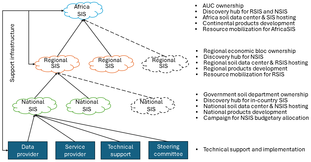
Figure 3.4: Framework for soil information systems governance in Africa
At the regional level, it is expected that the regional economic blocs will take ownership and overall responsibility for Regional Soil Information Systems (RSIS). The technical departments responsible for soil and agriculture at the regional bloc should host the SIS data center and server. In addition, the responsible departments should oversee (Figure 3.4):
- Coordination, standardization, resources mobilization, and capacity building on SIS matters in the economic region
- Development of soil information products at the regional level and use of soil information in the drafting of regional agreements and declarations touching on soils
- Harmonious implementation of SIS at the regional and national levels
- Guiding development of relevant policies and legislation promoting sustainable SIS in the region and countries of member countries/states
- Sensitization, awareness campaigns, and promotion of SIS in the regions and among member countries
- Developing partnerships and collaboration with other RSIS in Africa
SIS at the country level is expected to be owned by the government department responsible for soil matters in the country. The department will also take overall responsibility for the National Soil Information System (NSIS). The department will represent NSIS in all government deliberations touching on soil data and information in the country, develop appropriate policies and legislation for promoting soil health, and development and use of soil information in improving agricultural productivity and environmental sustainability in the country. The department will also often host the NSIS data center and server in addition to overseeing, although in some countries that function may be supported by other government agencies or parastatals under agreement (Figure 3.4):
- Standardized soil data collection and contribution to the NSIS
- Development of soil information products at the national level
- NSIS as the national soil data center serving soil data and information to all users in the country
- Partnership with NGOs, other institutions, and the private sector in shared agreement to contribute standardized soil data and information to a central NSIS in the country
- Guiding development of relevant policies and legislations and campaigning for national budgetary allocation for promoting sustainable SIS in the country
- Sensitization, awareness campaigns, and promotion of SIS in the country
3.4.4 Operational structure
Operational structures include SIS architecture and implementation setup necessary to ensure successful functioning of the SIS. SIS architecture is the arrangement of crucial components which constitute the system. The components include the server, programming interfaces, database, security, management models, software, and internet network (Figure 3.5). The choice and configuration of the architecture determines how soil data and information flow and is stored.
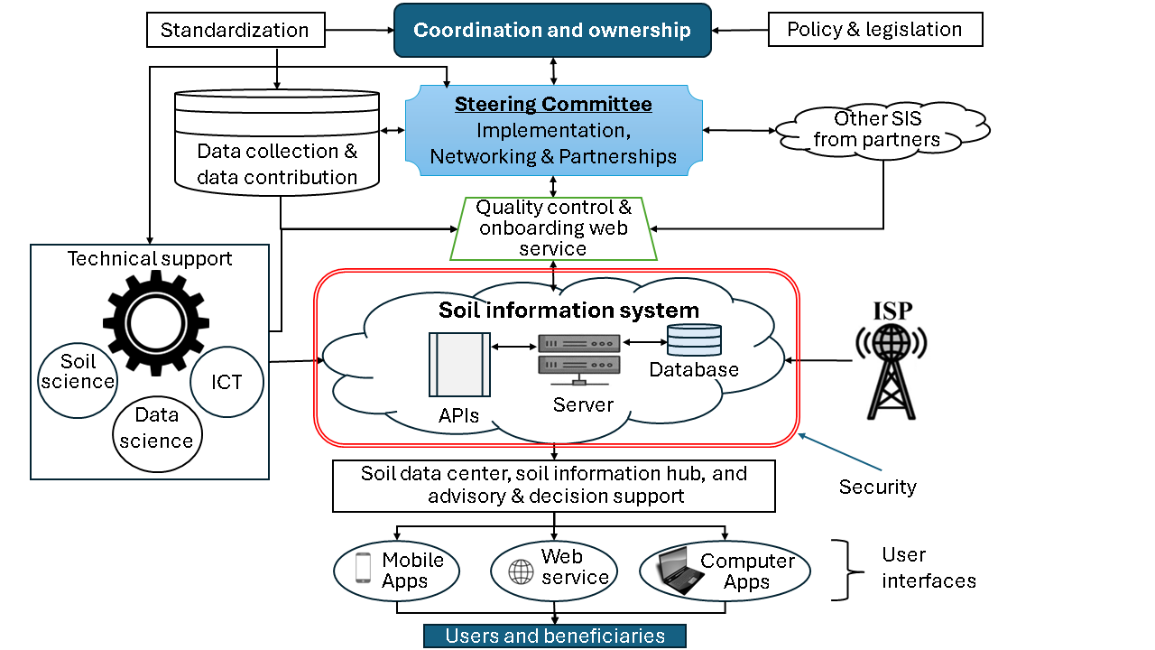
Figure 3.5: Design considerations for SIS in Africa
The following architectural considerations are proposed for the SIS development in Africa:
- Since it is expected that there will be inter-communication and information sharing between NSIS, RSIS, and AfricaSIS, the architecture will need to incorporate designs for inter-SIS information exchange,
- Most soil data in Africa comprise scanned maps, scanned soil reports, tabular soil data, digital maps, photographs, and digital documents. Some of these data types will have spatially georeferenced information. Therefore, the design data models are expected to consider these types of data diversity,
- SIS in Africa is expected to serve soil data and information to various users in and outside the continent. Therefore, its design should contain structures for data and information access (user interfaces) (Figure 3.5). These user interfaces should be designed to implement appropriate standards, methods, and tools for sharing soil data and information with users and beneficiaries. Some innovative tools such as mobile applications may be preferred particularly for smallholder farmers (Figure 3.5),
- Most soil data in Africa are held by different organizations. Therefore, the SIS design should incorporate facilities for allowing contributed data to be uploaded into the SIS, perform quality checks, and onboard the data into the SIS. The same facility can also be used for onboarding new data from field survey and laboratory analysis (Figure 3.5).
Implementation setup will ensure smooth and effective coordination of different parts of the SIS such as the technical support, SIS ownership, and SIS partners (such as data/service providers, other SIS, etc.) (Figure 3.5). The following points have been considered important to be incorporated in the design of a sustainable and effective SIS in Africa (Figure 3.5):
- Stable and easily deployable architecture for secure online management of soil information,
- Structured engagement with service providers and partners who are willing to share their soil data,
- Core team of technical support such as ICT, soil scientists, and data scientists,
- Use of standards, guidelines, protocols, and quality control for new/contributed data into the SIS.