2 Where we are: Status of SIS in Africa
2.1 Status of soil data
Soil data comprise measured soil properties, observations of soil characteristics, soil maps, soil reports, and images or photographs. The data is normally generated from field surveys, laboratory analyses, cartographic or digital soil mapping, documentation, or photographs. Soil data can be presented in form of tables, maps, documents, or images. Soil maps and profile data are the most common among researchers and soil information developers. Soil profile data consist of measured soil properties for observed layers in a vertical cross-section through the soil depth and a geo-reference. The data may also include other attributes/information related to land surface characteristics, soil forming factors, laboratory metadata, etc. Soil profile data is the results of field surveys combined with laboratory analysis.
This section describes soil data availability, age of available data, spatial coverage, number of soil properties covered, and extent in terms of soil depth in Africa. It also elaborates the status of soil profile data and soil maps in Africa.
2.1.1 Availability of soil profile data
Most soil profile data and maps in Africa have been generated by governments, the private sector, research organizations, and non-governmental organizations (NGOs). Information about available soil profile data from these sources was obtained from online databases, publications, and personal contacts. The information search targeted Soil Survey Departments in governments across Africa, ISRIC – World Soil Information (WoSIS) and the former Africa Soil Information Service (AfSIS), Food and Agriculture Organization (FAO) including the Global Soil Partnership (GSP) and the Harmonized World Soil Database (HWSD), soil science departments in universities or agriculture research organizations in Africa, and accessible online soil data repositories inside and outside Africa.
A preliminary analysis of available soil profile data in Africa showed that ISRIC (https://www.isric.org/projects/africa-soil-profiles-database-afsp, accessed on 30 June 2024) and FAO (https://www.fao.org/soils-portal/data-hub/soil-maps-and-databases/en/, accessed on 30 June 2024) have the most complete collection of soil profile database with wide coverage in Africa. There are also rich national soil profile datasets which countries have not publicly shared (Nenkam et al. 2024; C. T. Omuto et al. 2024). The analysis also showed that although the countries in Africa have soil profile data, the national coverage with the profile data is seemingly low. According to findable soil profile data, less than half of the countries in Africa seem to have more than 100 sampled soil profile locations in their database (Figure 2.1). There are also large parts of the continent, especially in the Saharan Desert, where soil profile data are scarce. This pattern of soil profile distribution also mirrors the distribution of areas in Africa with time-series periodic soil profile data collection. Routine soil profile data collection is currently not being implemented in many countries, which casts doubt on availability of monitoring data in most parts of the continent.
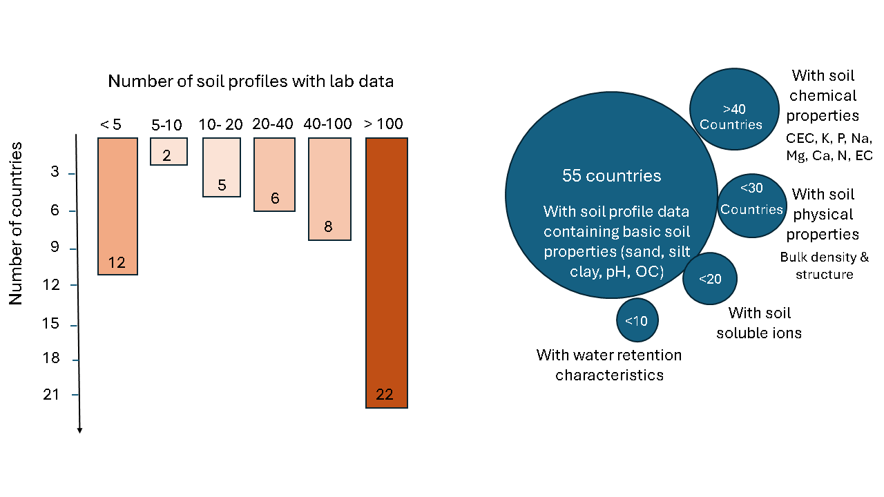
Figure 2.1: Soil profile data in Africa in April 2024
In terms of specific soil properties, it seems more than 70% of the countries in Africa have profile data containing basic soil chemical properties such as organic carbon (OC), total nitrogen (N), available phosphorous (P), cation exchange capacity (CEC), electrical conductivity (EC), and extractable/exchangeable cations like potassium (K), sodium (Na), Magnesium (mg), and calcium (Ca) (Figure 2.1). However, many countries do not seem to have accessible data on soil physical properties such as bulk density, fragment fractions, and soil structure. Similarly, soil properties related to water retention and infiltration characteristics and biodiversity are not adequately covered in most countries. A recent campaign was launched to sample Africa with more than 20,000 soil profile locations (https://www.soils4africa-h2020.eu/, accessed on 20 April 2024). This new effort is likely to bring in more soil data into accessible Africa soil database.
A soil spectral library for Africa has been set up at the World Agroforestry (https://doi.org/10.34725/DVN/MFHA9C, accessed on 20 April 2024). It contains soil spectral reflectance (such as Visible-infrared (VIS-NIR) and mid-infrared (MIR) reflectance) and corresponding selected measured chemical and physical properties of soil samples from several locations in Africa (Vågen et al. 2020; World Agroforestry (ICRAF) and International Soil Reference And Information Centre (ISRIC) 2021)
2.1.2 Soil maps and soil reports
Soil maps portray spatial distribution of soil information and include maps of soil types, soil properties, soil degradation, nutrient availability, rooting depth, etc. They are mostly produced either by the traditional cartography or digital soil mapping (DSM) methods. They are available as hard copies or in digital formats as scanned hard-copies or digitally developed maps. Traditional cartography often produce vector maps in nominal scales while DSM mostly produce raster maps (with pixels). Old vector soil maps in hard copies are available in Soil Departments in most countries. Some of these maps have been scanned and availed online within the countries or in publicly accessible portals such as WOSSAC (https://www.wossac.com/index.cfm accessed on 20 April 2024), FAO GeoNetwork (http://www.fao.org/geonetwork/srv/en/main.home, accessed on 20 April 2024), or EuDASM (https://esdac.jrc.ec.europa.eu/public_path/shared_folder/eudasm/africa/, accessed on 24 April 2024), etc. Most vector maps are exploratory soil maps and cover either whole country or a significant proportion of the countries. There are also pockets of detailed maps such as 1:50,000 or higher resolution that cover certain parts of agriculture potential areas. Like soil profile data, detailed vector soil maps do not cover most parts of the continent.
Continental level soil type maps are also available in digital formats at the scale of 1:3M as soil atlas of Africa (Jones et al. 2013) and at the scale of 1: 5M from the digital soil map of the world (FAO-UNESCO 1974). Besides the vector soil maps, there are also maps of soil properties, soil nutrient indicators, soil degradation, depths, etc. at the continental level and for various parts of Africa. Most of these maps have been developed using the DSM approach. For example, ISRIC and iSDA produced soil property maps for the continent (see https://www.isric.org/projects/soil-property-maps-africa-250-m-resolutionISRIC and https://www.isda-africa.com/isdasoil/, accessed 20 April, 2024). There have been attempts to make these maps freely accessible on websites, as downloadable computer packages, or on smart phones (Miller et al. 2018). An example can found in ISRIC soil grids (https://soilgrids.org/, accessed on 4 June 2024).
Soil reports document soil surveys, soil testing campaigns, or soil studies in general. They contain gray details which may not be found in soil maps and profile data. Most reports of soil surveys are in soil departments of the organizations which commissioned the surveys. Some of these reports have been scanned and are available at FAO (https://www.fao.org/soils-portal/data-hub/soil-maps-and-databases/soil-legacy-reports/en/, accessed on 20 April 2024), EuDASM (https://esdac.jrc.ec.europa.eu/public_path/shared_folder/eudasm/africa/, accessed on 24 April 2024), and ISRIC Library (https://www.isric.org/explore/library, accessed on 20 April 2024).
Existing soil profile data for Africa are scattered in different places. The continent needs a suitable access point for all these datasets or a central location as a repository to hold and manage the data for the benefit of soil data users. A central soil data center is necessary to either hold the freely accessible soil data in a central repository and/or act as link to other soil data held by different data holders through data-sharing agreements. Such a data center will require appropriate infrastructure and data management strategy to be able to continuously and sustainably update its data portfolio. The currently available soil data is a good starting point to develop the Africa soil data center.
2.2 Soil information systems in Africa
2.2.1 National soil information systems
A search for online findable and accessible soil information systems in Africa showed that only ten countries have national soil information systems and only five of these have online accessible national soil information systems (Figure 2.2). The five countries with online SIS still have more work to improve access and maturity towards FAIR soil data and information from their portals. Other countries with organized soil data such as Rwanda soil data (RwaSIS (http://maproom.meteorwanda.gov.rw/SOURCES/.Rwanda/.RAB/.soil/index.html, accessed on 20 April 2024)), Ghana soil information (https://www.csirsoilinfo.org/, accessed on 20 April 2024), Uganda soil information (https://lwasajames.wixsite.com/usis), etc. still need to improve their online data availability and visibility to users of soil information.
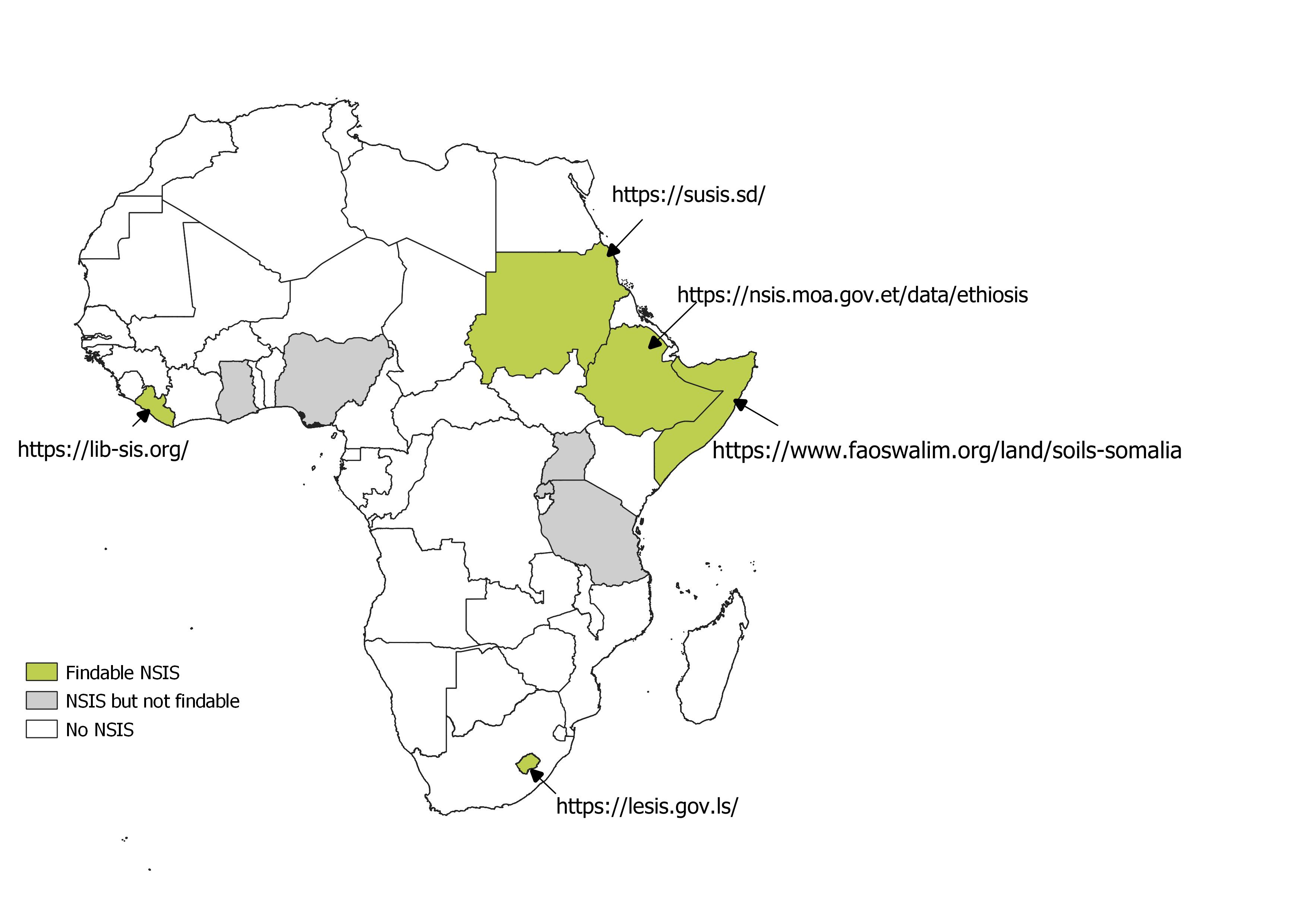
Figure 2.2: Soil profile data in Africa in April 2024
2.2.2 Regional and continental soil information systems
There are currently no regional soil information systems in the eight economic communities in Africa. In north Africa, some countries are partnering with ICARDA, soils4med (https://mel.cgiar.org/projects/1866), and the Global Soil Partnership (GSP) to develop a regional soil information system covering north Africa region. At the continental level, attempts were made to establish the Africa Soil Information Service (AfSIS). AfSIS generated and published significant amount of soil data and information (Hengl et al. 2015, 2021). The data is available at https://www.isric.org/projects/africa-soil-information-service-afsis (accessed on 20 April, 2024) and has been variously used to develop new continental soil information (see for example such as Africa soil property maps at https://www.isda-africa.com/, https://africasoils.info/, etc). Besides AfSIS, there were recent attempts to develop new soil information systems for Africa (see for example, https://www.isric.org/projects/soils4africa, accessed on 20 April 2024). All these developments are potential foundation to start developing a sustainable and resourceful Africa soil information system .
2.3 Availability of resources to support SIS development
The development of a soil information system is not only dependent on available soil data and reports, but also requires the necessary skills and knowledge to develop and maintain the SIS. Availability of accessible collection of resources for guiding SIS development, selection of appropriate architectures, standardization protocols, data-sharing policies, etc. can provide valuable support to institutions or organizations who want to set up SIS. Although there is no clear information on existing compendium of resources for SIS development, there are publications on various aspects of SIS development which are important references for SIS development in Africa (Burrough et al. 1984; Egmond et al. 2023; Palma et al. 2024). The ISRIC Resource Library (https://resources.isric.org/ , accessed on 4 June 2024) and CABI’s toolkit for data sharing (https://www.datasharingtoolkit.org/. Accessed on 4 June 2024) are also important resources which can benefit SIS development in Africa. There are also specific literature detailing technical and technological bottlenecks for data curation in Africa, which may be useful when considering SIS development in the continent (see for example (Nenkam et al. 2024)).