1.6 High pressure
Before we look at low pressure systems further, we should pause and consider what high pressure means for the weather. High pressure systems, or anticyclones, tend to be associated with fine summer weather. Air circulates clockwise around an anticyclone - the opposite to a depression.
Air in anticyclones tends to be descending towards the earth. This makes it difficult for air to rise and it is this that lead to clear skies with few clouds.
Semi - permanent areas of high pressure often develop over the Azores and Southern Europe. As these come north in the summer, they can serve to push depressions northwards, keeping them away from the UK. These anticyclones develop in the warm mid-latitude cell and are warm-cored features.
We also see areas of higher pressure between depressions, giving a temporary respite from poor weather. These develop in the cold polar air, are cold-cored and tend to move across the globe. They do sometimes warm through and stay put.
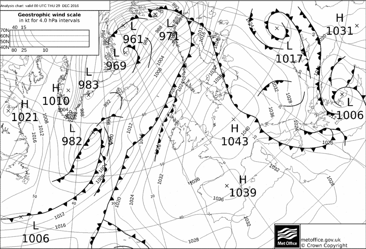
Blocking high over Northern Europe. The jet stream winds will tend to blow over the fronts marked to the west of the UK. This is likely to force low pressure 982 to the north, over Iceland and north of Norway. The South of the UK should have relatively settled weather. On the edge of the anticyclone, Scotland will experience high winds, and these may well intensify as the isobars become ‘squeezed’ by the low pressure passing north of the blocking high. Synoptic chart from UK Met Office, contains public sector information licensed under the Open Government Licence v1.0.
1.6.1 Fair weather cumulus clouds
Even in the fair weather caused by high pressure systems, there may be some clouds in the sky. As the sun shines and heats the surface of the earth, the air above the warm surfaces warms and starts rising. This warm rising air often contains moisture which condenses and forms clouds as it rises. The resulting puffy cotton-wool like clouds that form in the blue sky are known as ‘fair weather cumulus clouds’.
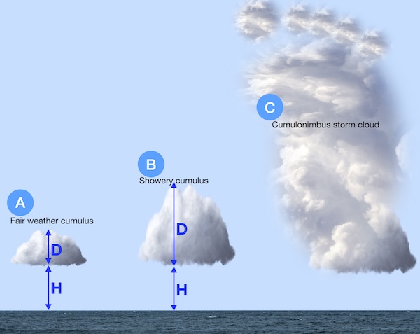
With these fair weather clouds (A in the diagram above), the depth of the cloud (D) is less than the height of the cloud (H).
If the process of warm, humid air rising and forming clouds continues, the cloud can eventually become deeper than its height off the ground (D>H), as shown as B in the diagram above. At this point, the cloud may return its moisture to the ground in a rain shower.
When warm humid air rises unchecked into the atmosphere, the cumulus clouds can become very deep indeed - perhaps 10 km tall! These towering clouds with dark bases are known as ‘Cumulonimbus’, or more commonly ‘thunderclouds’ (C in diagram above). The thunderstorms that they create can produce thunder, lightning, hail and strong localized winds.
If you see fair weather cumulus in the morning, it’s worth keeping an eye on the sky to see if they develop into taller clouds carrying showers, or even cumulonimbus storm clouds, through the day.